Kheerganga Trek 2026: Barshaini Route, Distance, No Camping
The Kheerganga trek as a day trek in 2026: the rules, the three routes from Barshaini, a section-by-section trail profile, ten years of weather by month, an hour-by-hour plan that fits the 10 am and 2 pm limits, and a 3-day plan from Delhi.

In this guide
- 01Is the Kheerganga trek open in 2026?
- 02The Kheerganga rules in one place
- 03Kheerganga trek distance and the three routes
- 04The trail section by section
- 05How hard is the Kheerganga trek?
- 06A 3-day Kheerganga plan from Delhi
- 07Best time for the Kheerganga trek, month by month
- 08Getting to Barshaini, and two valley risks
- 09Where to stay before and after the trek
- 10The hot spring and temple at the top
- 11What to carry for a Kheerganga day trek
- 12Doing the Kheerganga trek as a group
- 13Frequently asked questions
- 14 min to go
The Kheerganga trek climbs from Barshaini, the last road head in the Parvati valley, to a hot spring and Shiva temple on a meadow high above the river. In 2026 it is a day trek only, so the plan that worked in a 2019 blog no longer does.
How long is the Kheerganga trek and can you camp at the top?
Kheerganga is a walk of about 12 to 13 km each way from Barshaini, past Nakthan and Rudranag, to a hot spring roughly 600 m higher. Camping has been banned since July 2024: reach the top before 10 am, start down by 2 pm, and sleep in Barshaini, Kalga, Nakthan or Tosh. Leave Barshaini by 4:30 am.
The short answer
Day trek only: no tents or stays at the top since July 2024, and no order lifting the ban as of November 2026.
The Nakthan route is the main one. About 450 m of its roughly 600 m gain comes after Rudranag, in the last third of the walk.
The Forest Department named April to October as the permitted season in February 2025. Check before a winter trip.
Leave Barshaini by 4:30 am and turn back if you are not at Rudranag by 6:45 am.
Is the Kheerganga trek open in 2026?
Yes, as a day trek. We found no 2026 notice closing the trail or lifting the 2024 camping ban, and every current guide we read describes it as day-only.
Two things to know before you book a bus:
The season. In February 2025 the Parvati division forest officer told The Tribune that permission for the route runs from April to October. The report doesn't say the trail is closed from November to March. We found no public phone line for the Parvati forest division, so for a winter date ask your Barshaini homestay and the forest staff on the trail first, and read our Kheerganga in winter guide for snow and start times.
The road. The Manikaran–Barshaini road at Ghatigad has had repeated slides. In April 2026 a car was hit and burnt out there, and The Tribune reported the stretch was closing two to three times a week. Keep half a day spare.
The Kheerganga rules in one place
The rules come from two statements by the Parvati division forest officer, reported by The Tribune in July 2024 and February 2025. Nothing newer has replaced them as of November 2026.
| Rule | What it says | Announced |
|---|---|---|
| No camping | No tents or overnight stays in the Kheerganga area | July 2024 |
| Time limits | Reach before 10 am, return by 2 pm | July 2024 |
| Where to sleep | Nakthan, Barshaini, Kalga or Tosh | July 2024 |
| Season | Permission for the route from April to October | Feb 2025 |
| Daily cap | 320 trekkers a day | Feb 2025 |
| Checkpost | Planned, to record trekkers for rescues | Feb 2025 |
The camping ban was announced in July 2024 after tents on the meadow reached about 500. It was "for the time being", but we found no order lifting it.
"Return by 2 pm" is read by guides as leaving the top by 2 pm. Confirm it on the day: if staff say it means back at Barshaini, a full trek won't fit, so walk to Rudranag instead. If the 320-a-day cap is enforced, a late group on a busy weekend could be turned back, one more reason to start early.
A fee is less clear. HimSafar's August 2026 guide mentions about ₹100 per person at a checkpost near Barshaini and says to confirm locally, while Travel Coffee's June 2026 guide says no formal permit is needed. Carry photo ID and some cash, and follow what forest staff tell you on the day.
If a package or an old blog offers a tent at the top, it contradicts these rules. Ask the seller how before you pay.
Kheerganga trek distance and the three routes
The main route via Nakthan is about 12 to 13 km each way; the forest officer described the track as 13 km in 2025. Trek guides put the Kalga route at about 14 km and the Tosh route at about 17 km.
| Route | One way | Mapped line | Best for |
|---|---|---|---|
| Barshaini via Nakthan | 12–13 km | 8.8 km | First-timers, the dark, food stops |
| Barshaini via Kalga | about 14 km | 9.2 km | Forest, a quieter walk |
| Tosh | about 17 km | not mapped | Groups already staying in Tosh |
Plan your day on 12 to 13 km. The "mapped line" column is the length of each trail as drawn on OpenStreetMap, which smooths out the many small bends, while guide figures are often rounded up. Treat the mapped line as a lower bound and use it only to compare routes.
The Kalga trail runs through more forest and joins the Nakthan trail near Rudranag. Guides describe it as less clearly marked in places, so in the dark, take Nakthan.
The trail section by section
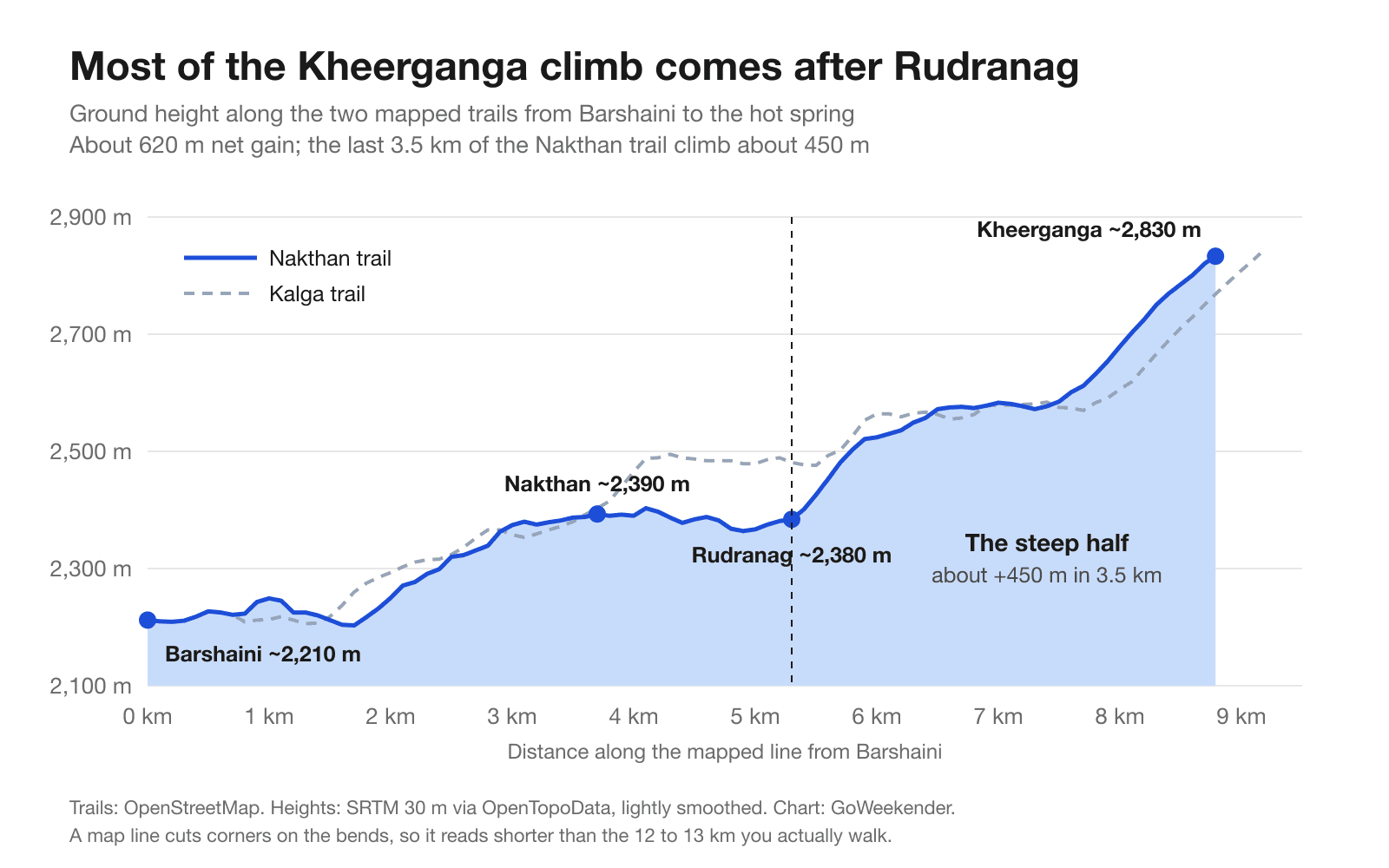
Most of the work comes late. On the map, the first 5 km to Rudranag gain only about 170 m, and the last 3.5 km climb about 450 m to the meadow. On foot both stretches are longer. That is why the turn-back point sits at Rudranag: the easy half tells you little about the hard one.
Barshaini to Nakthan
From the bus stand the path crosses the Parvati and climbs gently to Nakthan, a small village of dhabas and guesthouses at about 2,390 m. Plan on about 1.5 hours. This is the easy part, so don't race it in the dark.
Nakthan to Rudranag
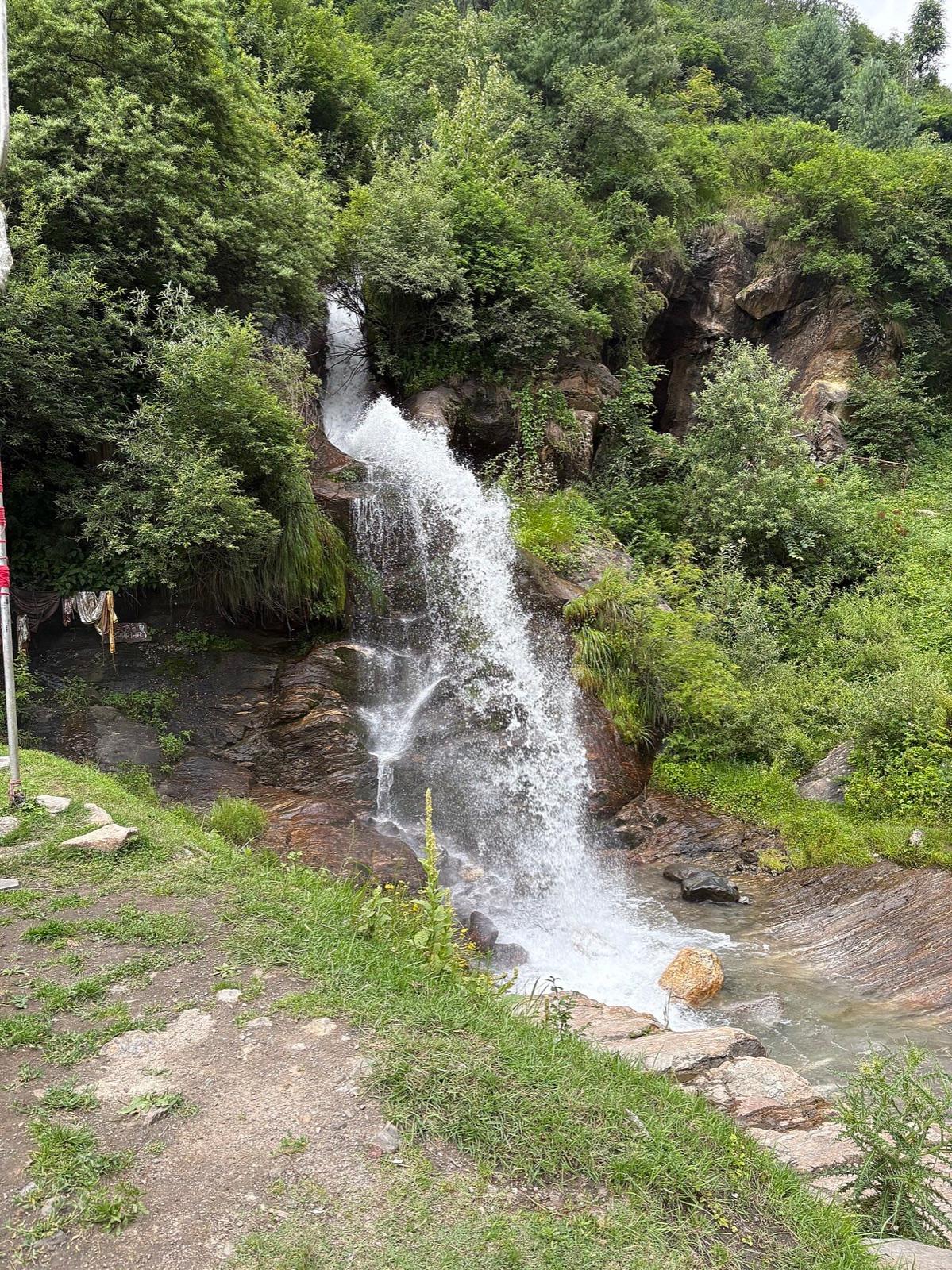
The path stays fairly level and even dips a little to Rudranag, where a small Shiva temple sits beside a waterfall at about 2,380 m. Treat it as your checkpoint: if the slowest walker isn't here by 6:45 am, turn back. The climb above takes 2 to 3 hours, so a later arrival risks missing 10 am.
Rudranag to the top
From Rudranag the trail climbs steadily through forest. The forest department planned a checkpost in 2025; OpenStreetMap now marks a Forest Department checkpoint about a kilometre past Rudranag. The last kilometre is the steepest, then the forest opens onto the meadow at Kheerganga. Plan 2 to 3 hours for this half.
How hard is the Kheerganga trek?
It is a moderate trek made hard by the clock. The climb itself is steady rather than technical, but you walk 24 to 26 km in one day, start in the dark and race two cut-offs.
HimSafar's August 2026 guide puts it at 4 to 6 hours up and 3 to 4 hours down on a dry trail. With two to four hours at the top, that is an 11 to 13 hour day.
It suits:
people who walk 15 km on a weekend without trouble
groups willing to turn back at a set time
anyone with broken-in trekking shoes and a headlamp
It doesn't suit someone who hasn't walked more than a few kilometres in months. For them, the walk to Rudranag and back is a good day out on its own.
A 3-day Kheerganga plan from Delhi
Two nights near the trail and one long day on it. This plan assumes April to October and the main Nakthan route, with a night in Barshaini or Kalga before the trek so the 4:30 am start is a short walk, not a drive.
Night 0: Delhi to Bhuntar
Take an overnight bus from Delhi to Bhuntar. Our 3-day Kasol itinerary has the bus options and the Bhuntar transfer.
Day 1: up the valley to Barshaini or Kalga
Cab or local bus from Bhuntar past Kasol to Barshaini; Kasol to Barshaini is about 16 km and 40 minutes when the road is clear. Check in at Barshaini or Kalga, walk a little to loosen your legs, pack tonight and sleep by 9 pm.
Day 2: the trek, hour by hour
4:00 am: wake up, eat something, fill 2 litres of water each
4:30 am: leave Barshaini with headlamps on (from Kalga, 20 to 30 minutes earlier)
6:00 am: Nakthan, short stop
6:45 am: Rudranag. Not here yet? Turn back.
9:30 am: reach the meadow, inside the 10 am limit
9:30 am to 1:30 pm: the spring, the temple, lunch
1:30 pm: start down, inside the 2 pm limit
5:00 to 5:30 pm: back at Barshaini
Sunset in mid-October is about 5:45 pm, earlier behind the valley walls, so on this plan you finish in daylight. From November the light goes earlier: use the winter timings.
Day 3: Manikaran and home
Sleep in, stop at Manikaran Sahib Gurudwara on the way down, and take the evening bus back to Delhi from Bhuntar.
Want a group and a base without planning the logistics? Hosted trips that stay in Tosh, one of the villages the forest department named, are below. Check each trip's plan for whether it includes the trek.
Escapes to Tosh
Best time for the Kheerganga trek, month by month
Go in October, or from late April to early June. October is the driest month inside the permitted season, while late spring is green with longer days. Avoid July and August.
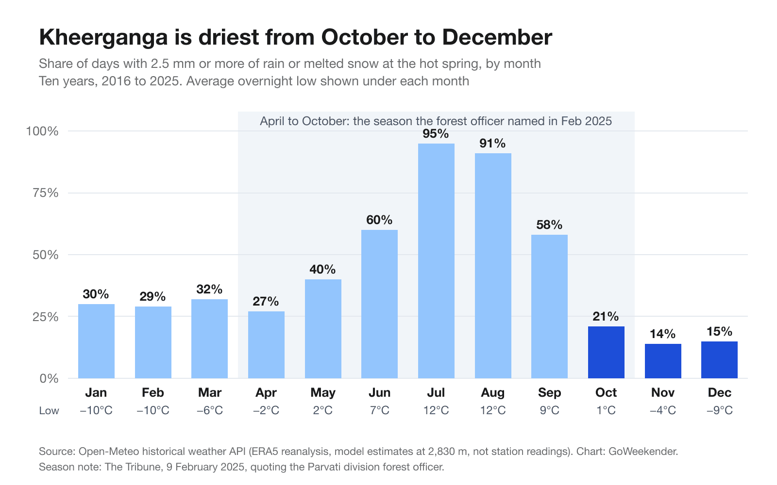
These figures are ERA5 reanalysis estimates from Open-Meteo for 2016 to 2025 at the spring's height, not weather-station readings, and a "wet day" means 2.5 mm or more of rain or melted snow. They show:
October: rain or snow on about 21% of days, average overnight low about 1°C. The best month for most groups.
April to early June: wet on 27 to 40% of days, lows from about −2°C in April to 7°C in June. Snow can linger near the top in April and slow the climb, so allow extra time or pick May.
July and August: wet on more than 90% of days, lows about 12°C. Slippery rock above Rudranag and slides on the road. Skip it.
September: wet on 58% of days, lows about 9°C, drying through the month. Go late in the month if you go at all.
November to March: November and December are the driest months (14 to 15% wet days), but they fall outside the named season, with lows of about −4°C and −9°C and snow from late December. See the winter guide.
Getting to Barshaini, and two valley risks
From Delhi it's an overnight bus to Bhuntar, then about 50 km up the valley via Kasol and Manikaran to Barshaini. Book the bus for the night before Day 1, not the night before the trek.
zingbus listed 13 buses a day from Delhi to Bhuntar in November 2026, taking about 10 hours, at fares from ₹546 to ₹2,606 (zingbus, Delhi to Bhuntar). Local bus and cab fares up the valley, and a cost split for four, are in our 3-day Kasol itinerary.
Two risks that most guides leave out:
The Ghatigad slide zone. The road past Ghatigad, below Barshaini, has been slide-prone since 2023 and was closing two to three times a week in April 2026. Leave yourself a spare half day, and don't sit under the slope if traffic stops.
Sudden river rises. In May 2025 two tourists were swept away near Kasol by a sudden rise in the Parvati that The Tribune linked to a water release from the Barshaini dam; a judicial inquiry was ordered. In June 2025 NHPC began installing hooters and voice alerts at 18 points between Barshaini and Jari. Don't count on hearing one: stay off the rocks in the river bed, and move up the bank the moment the water rises or a siren sounds.
Where to stay before and after the trek
Sleep in Barshaini or Kalga for the shortest pre-dawn walk to the trail. Nakthan puts you 1.5 hours further along. Tosh works if you take the Tosh route or don't mind an extra walk.
Barshaini: the road head, with dhabas and guesthouses by the bus stand. Easiest for a 4:30 am start.
Kalga: a short walk above Barshaini, quieter, with homestays among apple orchards. Use the Kalga trail or walk back down to Barshaini.
Nakthan: a few basic guesthouses on the trail itself. A good choice if you arrive early on Day 1.
Tosh: the most cafés and stays, across the side valley. Read how a Kasol group trip works if you want to build a longer week around it.
Pulga, a short walk from Barshaini, also has guesthouses. Kasol has the most choice of all but adds a 40-minute drive before dawn.
The hot spring and temple at the top
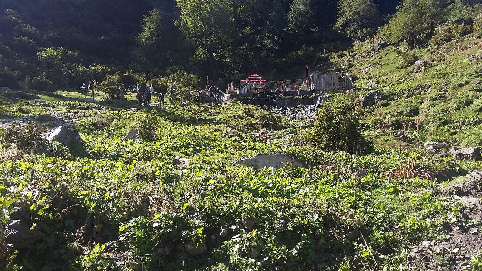
At the top is a hot spring beside a small Shiva temple. Old photos show a single open pool; reports from 2026 differ on what is open now, so check when you arrive. Either way, the 2 pm rule gives you a few hours, not an evening.
Don't use soap or shampoo in the spring water.
Pack a quick-dry towel and a change of clothes.
Leave the temple area as you found it, and take all your waste back down.
What to carry for a Kheerganga day trek
Pack for 12 hours on the trail with no stay at the top. Nakthan and Rudranag usually have small dhabas in season, and we couldn't confirm what still operates on the meadow since the 2024 ban, so carry your own lunch.
A headlamp each, with spare batteries
Trekking shoes with a deep grip, already worn in
A rain jacket, plus a fleece for the cold top in April and October
2 litres of water each, and a packed lunch with snacks
Photo ID and cash
A towel and spare clothes for the spring
A small first-aid kit and personal medicines
A bag to carry your waste back down
Plan for little or no phone signal above Nakthan. Leave your plan with your homestay before you go.
Doing the Kheerganga trek as a group
A group moves at the speed of its slowest walker, and the 10 am limit doesn't bend for anyone. Agree three things the night before.
The turn-back point. Rudranag by 6:45 am, or the whole group turns round together.
The meeting points. Regroup at Nakthan, Rudranag and the top, so nobody waits alone in the dark.
The start-down time. 1:30 pm from the spring, whatever anyone says at 1:25.
Groups of more than six do better as two smaller groups with a leader each. Pair people up on the way down, and keep the last pair in sight. If someone is hurt where there's no signal, one pair stays with them and another walks down until they can call 112.
New to trekking with people you met online? Read how to travel safely with strangers before you go.
Frequently asked questions
Is the Kheerganga trek open in 2026?
Yes, as a day trek. We found no 2026 notice closing it or lifting the July 2024 camping ban. In February 2025 the forest officer named April to October as the permitted season, so ask locally before a winter trip.
Can you camp at Kheerganga?
No. The Himachal Forest Department banned camping in the Kheerganga area in July 2024, and we found no order lifting it as of November 2026. Stay in Barshaini, Kalga, Nakthan or Tosh, and do Kheerganga as a day trek.
How long is the Kheerganga trek?
About 12 to 13 km each way from Barshaini on the main Nakthan route, so 24 to 26 km in the day. The Kalga route is about 14 km each way and the Tosh route about 17 km.
How many hours does the Kheerganga trek take?
Plan 4 to 6 hours up and 3 to 4 hours down on a dry trail, plus time at the spring. Leave Barshaini by 4:30 am so you reach the top before 10 am and can start down by 2 pm.
Which is the best route to Kheerganga?
The Nakthan route from Barshaini. It is the most used, the easiest to follow in the dark and has food stops at Nakthan and Rudranag. The Kalga route is quieter forest but less clearly marked in places.
What is the best time for the Kheerganga trek?
October, or late April to early June. Ten years of model data show rain on about 21% of October days at the spring, against more than 90% in July and August. November and December are drier but fall outside the April to October season.
Is the Kheerganga trek difficult for beginners?
The path isn't technical, but the day is long: 24 to 26 km, a net gain of about 600 m with more ups and downs on the way, and a dark start. A fit beginner can manage it with a group. If you rarely walk far, do the walk to Rudranag and back instead.
Is there an entry fee or permit for Kheerganga?
Reports differ. HimSafar's August 2026 guide mentions about ₹100 per person at a checkpost near Barshaini; Travel Coffee's June 2026 guide says no formal permit is needed. The forest department planned a checkpost in 2025 to record trekkers. Carry photo ID and some cash.
How high is Kheerganga?
Guides usually say about 2,960 m. Three public terrain models put the meadow and spring at about 2,760 to 2,850 m, with Barshaini at about 2,210 m. That makes the net gain about 550 to 750 m depending on which figure you trust, with more climbing on the ups and downs.
Can you do Kheerganga in one day from Kasol?
Only with a very early start. Kasol to Barshaini is about 40 minutes by road, so you would leave Kasol by about 3:45 am and drive the Ghatigad slide zone in the dark. Sleeping in Barshaini or Kalga the night before is much easier and safer.
Find your Parvati valley crew
Join a verified group trip or plan your own with friends on GoWeekender.
Get the appGoing with friends? Send it to the group.

Written by
GoWeekender Team
We're the team building GoWeekender, the app that matches verified travellers across India by vibe, budget and pace. We write about what we learn planning group trips.
First published